|
|
Weather & Global Quake Maps
Maps and Data provided by the U.S. Geological Survey (USGS), National Oceanagraphic & Atmospheric Administration (NOAA), the National Weather Service (NWS), and Sanghi IT Laboratories (SITL).
Weather Information Maps for The United States

Satellite Imagary of Cloud formation and density.
|
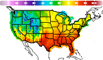
This is a map showing the maximum temperatures. The higher temperatures are towards or in the red spectrum.
|
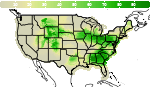
This is a map showing the percent liklihood of percipitation. The greener areas being the most likely to have rain.
|
Global Earthquake Map
The points plotted on this map are in real time and correspond to the earthquake data to the right of this page.
As you can see from the key below the map the size of the square on the map used to indicate the location of the epicenter of the earthquake is directly
porportional to the magnitude of the earthquake itself.


|
|

 Powered by Sanghi Information Technologies